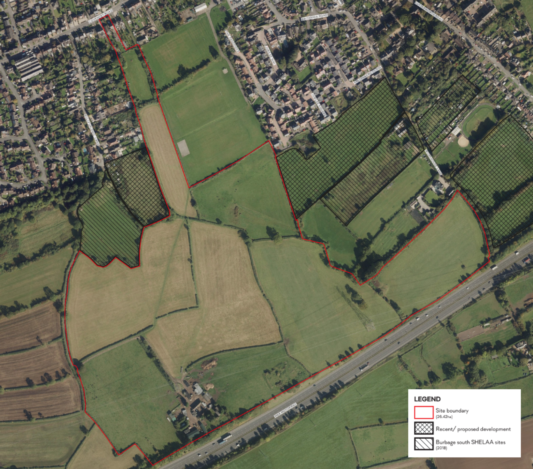
The approximately 27 hectares site is located between the southern extent of Burbage and the M69 motorway.
The site adjoins the existing settlement of Burbage to the north and east. To the north-east and west is agricultural land and to the south is the M69 forming a barrier to the open countryside beyond.
The eastern parcel of the site, off Lutterworth Road, already benefits from Outline Planning Permission for up to 80 homes. 55 of the 420 homes proposed will be delivered on this parcel.
Site location plan - click to enlarge
The hybrid planning application is for a new neighbourhood of 422 high-quality homes set within extensive areas of landscaped public open space. In line with local planning policy, 20% of the new homes would be affordable homes for local key workers, first-time buyers and those on lower incomes. We will also be delivering bungalows as part of the mix of homes. 11 Self-Build Plots are also being provided to enable people to build their own homes to their own specifications and needs. In addition, 54% of the new homes will be built to adaptable standards, delivering dwellings that can be adapted to the changing needs of householders.
In addition to the proposed new homes, a site is also being provided for a c66-bed Care Home. This element of the planning application is Outline and will be developed in more detail once the principle has been established, enabling it to be designed to the requirements of the Care Home operator. Existing trees and hedgerows across the site will be retained wherever practicable, with habitats being enhanced with additional planting within the extensive areas of green public open space. This will create a comprehensive network of ecological and wildlife corridors.
Public rights of way will be enhanced, including improvements to the Burbage Round, alongside the creation of a network of new footpaths and cycleways connecting the new neighbourhood with the existing residential areas to the north and east of the site, and providing links onwards to the shops, restaurants and facilities of the village centre.
There has been a sustained lack of housebuilding nationally over the last 50 years. There has also been a continual rise in the demand for homes as people live longer. The recent impact of COVID-19 has encouraged people to work from home, resulting in many people looking for larger homes to accommodate this requirement. There are local shortages of both open market and affordable homes, and it is getting harder for local people to afford homes in the area. In this context, the Government has set a clear requirement for Local Authorities to “significantly boost the supply of housing”.
Yes. In line with the policy of Hinckley and Bosworth Borough Council, 20% of the new homes will be affordable homes for key workers, first-time buyers and local people on lower incomes. The affordable housing mix proposed includes 1, 2, 3 and 4 bed homes, including a number of bungalows.
Yes. We are delivering bungalows as part of the mix of homes, available both as open market and as part of the affordable housing provision.
The neighbourhood will be served by a primary access from Coventry Road. A small section of the development to the east of the site will have a dedicated access on to Flanders Closebut there will be no vehicular link between this parcel and the main site. There will therefore be no vehicular link between Flanders Close and Coventry Road, but there will be pedestrian and cycling links. The access from Coventry Road is being facilitated by the removal of two properties owned by Redrow.
The access from Coventry Road forms the spine road into the site and will be designed as a tree-lined Avenue, facilitating bus access. The spine road will be bordered by a 2m footway and 3m cycleway.
We are also designing the neighbourhood to provide the potential for an additional vehicular access to Rugby Road, west of the site, as part of any future development in that area.
A detailed Transport Assessment has been produced as part of a planning application in line with current government and local policy guidance. This report assesses the highway safety and capacity of the surrounding highway network and demonstrates that access from Coventry Road can be safely accommodated without detrimentally impacting the surrounding highways network.
There is an Outline Planning Consent in place for up to 80 homes on the southeastern parcel of the site off Flanders Close. 55 of the proposed 422 will be delivered on this parcel. Access to this parcel of 55 homes will be from Flanders Close, but there will be no vehicular connection between this parcel of homes and the rest of the site. There will only be pedestrian and cycle connectivity between Ambion Way and Coventry Road with no vehicular connection.
Nearly 40% of the new neighbourhood will be retained as green public open space, including the retention and enhancement of existing green corridors, retention of existing trees and hedgerows within the site wherever possible, and extensive new planting of trees and hedgerows.
An Arboricultural Assessment has been undertaken, which assessed trees along and within the boundaries of the site, along with a number of hedgerows. These existing natural assets will be retained and protected as part of the proposals.
The only removal of existing hedgerows and trees that will be required, relates to facilitating the vehicular access from Coventry Road, along with the internal highway network. However, the proposed development would also make provision for extensive planting of new trees and hedgerows planting within the open space and along boundaries. The proposed development provides an opportunity to improve and increase tree cover in the local area without the loss of any arboriculturally significant trees or hedgerows.
Existing Public Rights of Way will be retained and enhanced, including improvements to the section of the Burbage Round walking route that passes through the site. There will also be the creation of a network of new footpaths and cycleways connecting the new neighbourhood with the existing residential areas to the north and east of the site, and providing links onwards to the shops, restaurants and facilities of the village centre.
Yes. The site is currently largely comprised of improved agricultural grassland, which is of relatively low value in terms of biodiversity. By retaining and enhancing existing hedgerows, incorporating them into a network of wildlife corridors through the neighbourhoods, as well as the introduction of wetlands habitats through the Sustainable Urban Drainage System (SUDs), extensive planting of additional new trees, and features such as bat boxes and bird boxes, we are working to ensure we deliver Biodiversity Net Gain across the site.
The development would generate significant financial contributions to be invested into local infrastructure and services such as GP surgeries, dentists, education, public transport etc. This will be determined by statutory consultation on the planning application, carried out by the Local Planning Authority with bodies such as the local NHS, the Local Education Authority, etc.
This process is ongoing, however the following financial contributions have so far been suggested through consultation to be provided by the development:
- Nearly £2.2 million to increase capacity in local Primary Education
- Circa £1.2 million on capacity in local Secondary Education
- More than £600,000 for Early Years provision
- Around £250,000 for Post-16 education locally
- More than £220,000 for SEND provision
- Circa £330,000 to support local GP provision
- Over £12,500 to be invested in Burbage Library
- Over £21,000 on improving facilities at the local Household Waste and Recycling Centre
A detailed Transport Assessment has been produced as part of a planning application in line with current government and local policy guidance. This report assesses the highway safety and capacity of the surrounding highway network and demonstrates that access from Coventry Road can be safely accommodated without detrimentally impacting the surrounding highways network.
A Drainage Strategy and Flood Risk Assessment has been prepared for the development of the site. The Environment Agency Flood Maps confirm that the site is located within Flood Zone 1 (lowest risk of flooding).
Surface water discharge will be kept at the existing Greenfield Runoff rates to ensure that the proposed development remains safe and does not increase flood risk or incur any adverse impacts on the surrounding area.
Existing surface water flooding associated with a watercourse crossing part of the site has been identified and a Drainage Strategy has been prepared for this which incorporates Sustainable Drainage Systems (SuDS) and which will assist in managing and improving the existing surface water situation. The incorporation of SuDS also plays a dual role, as it will be incorporated into the site’s public open space, which also offers many environmental benefits and provides amenity value to the proposed public open space.
The southern area of the site will take account of the noise from the adjoining M69. A Noise Survey and Assessment has been undertaken at the site.
The Noise Survey and Assessment identifies that mitigation measures will need to include an appropriate separation distance between the motorway and the nearest dwellings, along with site layout optimisation. An acoustic barrier is also proposed along the southern boundary adjacent to the M69. The required mitigation measures identified will be fully implemented into the scheme proposals.
The Burbage Neighbourhood Plan 2015- 2026 was formally made by the Council on 10 May 2021, following a local referendum supporting the plan, and it now forms part of the Development Plan for Hinckley and Bosworth Borough. Policy 1 (Settlement Boundary) of the NP is clear that “Residential development on land within or adjacent to the settlement boundary, as shown on Figure 2, page 19 will be supported, subject to complying with other development plan policy.” Although the site is beyond the Burbage Settlement Boundary, it does adjoin it at several points. In this context, the principle of residential development is clearly supported by the Burbage Neighbourhood Plan.
In addition to according with the Neighbourhood Plan, the emerging plans will be policy compliant in other respects, including provision of affordable homes, provision of public open space, development density, housing mix and design.
We submitted an outline planning application for 80 homes, which was recommended for approval by the Planning Department at Hinckley and Bosworth Borough Council. This was subsequently refused at Planning Committee, contrary to the recommendations of planning officers. As the application was recommended for approval by the Council’s Planning Department, the planning committee’s decision was appealed and the refusal was overturned by the Planning Inspectorate and outline planning permission granted. This parcel is incorporated into the wider plans and 55 of the 422 homes will be provided here, informed by the existing outline planning consent.
This would be dependent on the planning process, but we anticipate that, subject to planning, work to deliver the new homes may be able to start in 2025.